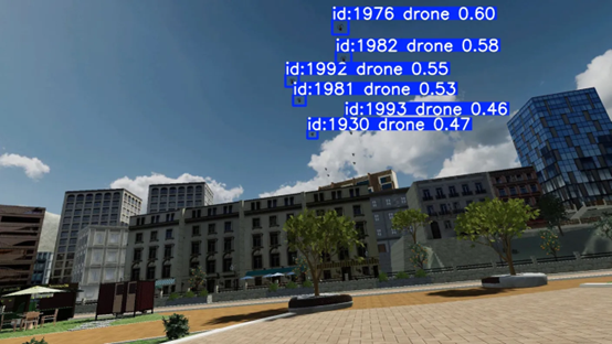
Visual Pollution Assessment of UAM through Virtual reality, Augmented reality & Deep Learning
- ImAFUSA

- Feb 8, 2024
- 2 min read

Urban Air Mobility (UAM) is poised to revolutionise transportation in densely populated areas, offering faster and more efficient modes of travel. However, as the use of UAM vehicles increases, concerns about noise pollution and environmental impact have emerged. Addressing these concerns requires comprehensive analysis and mitigation strategies. In this article, we explore how deep learning techniques, integrated into Virtual/Augmented Reality (VR/AR) technologies, can enable large-scale analysis of UAM noise and environmental acceptance, leading to informed decision-making and sustainable urban development.
The advent of UAM vehicles, including electric Vertical Takeoff and Landing (eVTOL) aircraft, drones, and air taxis, has the potential to transform urban transportation systems. However, the increased use of these vehicles raises concerns about noise levels, air quality, and community acceptance. Traditional methods of analysing noise and environmental impact rely on limited data sources and may lack the scalability needed to address the complexities of urban environments.
Visual Pollution in UAM and the role of VR/AR
Visual pollution in urban environments can take many forms, from cluttered skylines to the intrusive presence of technology in natural landscapes. In the context of UAM, visual pollution refers to the potential for aerial vehicles to disrupt the visual harmony of a city or landscape. As urban skies become increasingly populated with drones and air taxis, the challenge of assessing and mitigating their visual impact becomes critical.
VR/AR technology provides a unique solution to this challenge. By creating immersive simulations of urban environments with integrated UAM systems, VR/AR enables city planners, designers, and the public to visually experience and assess the impact of aerial vehicles on cityscapes before they are physically introduced.
Integrating VR/AR and Deep Learning for UAM Visual Pollution Assessment
Complementing VR/AR with emerging Deep Learning capabilities enables the proliferation of the tools necessary for analysing and understanding the visual data generated within VR environments. By training deep learning models on various urban landscapes, both with and without UAM integration, these models can learn to identify patterns, trends, and outliers in visual pollution thus allowing advanced UAM-related analytics to be delivered, e.g.:
Flight Path Optimisation: Deep Learning algorithms can analyze terrain features, land use patterns, and environmental constraints to optimise UAM flight paths and minimise visual intrusion. VR/AR simulations can visualise these optimised flight paths, enabling stakeholders to evaluate their compatibility with surrounding landscapes and identify potential conflicts.
Stakeholder Engagement and Decision-Making: VR/AR environments can facilitate stakeholder engagement by providing immersive experiences that allow residents, policymakers, and urban planners to visualise UAM-related developments and provide feedback. Deep Learning-based analytics can inform decision-making by predicting visual pollution levels, assessing mitigation measures, and evaluating the effectiveness of regulatory policies.
Numerous benefits of analytic workflows
Developing analytic workflows for visual pollution assessment in UAM scenarios offers numerous benefits, including cost efficiency, comprehensive analysis, predictive modelling, and collaborative data sharing. As UAM continues to evolve, the development and adoption of such workflows will play a crucial role in promoting sustainable urban development and the acceptance of UAM initiatives.
The ImAFUSA project will leverage data from VR tools and interviews, combined with image analysis and deep learning techniques, to provide a first proof-of-concept that stakeholders can gain valuable insights into visual pollution annoyance across different landscapes and deployment scenarios.


